Sunday, June 29, 2014

Independence Monument


I went hiking in Monument Canyon, home to many of the spectacular monoliths for which Colorado National Monument is known. The most iconic is called Independence Monument, shown below. It's a red-sandstone rock tower standing at roughly 450 feet, the last piece of an ancient canyon wall that has collapsed a little at a time over the last few million years.

A little bit of history: John Otto is the guy who relentlessly pushed for Colorado National Monument to be set aside as a park in the early 1900s. Some call him a free-spirit, but most say he was a total nut. He lived in the canyons by himself for close to a decade, got married in the canyon now named Wedding Canyon (it didn't last), and sent a lot of letters to the White House arguing for this area to be protected. In 1911, President Taft officially signed for the Monument, and Otto became the park's first official custodian. 

Otto created the first route up Independence Monument, carving steps and even drilling holes into which he put iron bars. The bars have since been removed for safety reasons, but the steps are still used by climbers today. Otto used to climb up with an American flag and fly it on top of the tower. The tradition has continued, and on the 4th of July the local Search and Rescue team leads climbers up with a flag and apparently people hike in to the base to watch and cheer for them. I'm looking forward to seeing it on Friday!


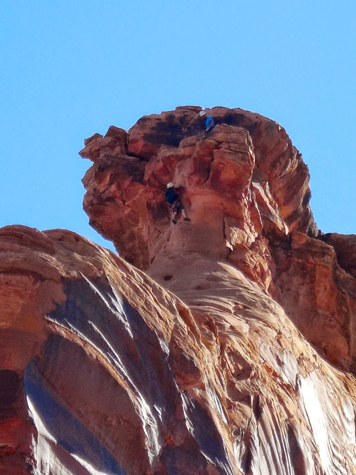
I happened to notice some climbers while I was eating a snack at the base of Independence. This is a picture of the climbers with my camera on maximum zoom. They are WAY up there. 


After watching for a while, I kept hiking up the canyon. Once I got up a little higher, I looked back and you could see two little tiny dots up on top. You can click on the photo to enlarge it. They made it!


Check out some more photos of climbers on this site: http://www.supertopo.com/rock-climbing/Desert-Towers-Independence-Monument-Ottos-Route

Monday, June 23, 2014

Hiking on the Grand Mesa

Yesterday I drove up to the Grand Mesa, about an hour from where I live in Fruita. According to the GPS, I parked above 11,000 feet and it was all uphill from there.

I hiked the Crag Crest Trail, in the Grand Mesa National Forest. The hike was awesome - about 2 miles are along an exposed ridge where you can see many miles in every directions. Here are a few photos from my hike. You can read more about where I was here: http://www.gjhikes.com/2010/07/crag-crest-loop.html


 Yes -- there were places where I had to go around snow drifts. But it wasn't cold - I hiked in shorts and a t-shirt.


Saturday, June 21, 2014

Canyons & Lizards!

This week was training for my role as an interpretive ranger this summer. Once I'm in the regular rotation, days will consist of giving short talks (geology talks in the morning, various presentations in the afternoon, or evening programs in the campground), staffing the information desk in the visitor center, or roving the trails to provide more informal interpretation. Yes - roving means I get to go hiking during work time.

Here are a few highlights from week one:

• Wednesday afternoon, I drove the entire park, 23 miles, along historic Rim Rock Drive, which follows the rim of the canyons. I stopped at all the overlooks, read all the signs, and talked with park visitors. In all, the drive took me about 3.5 hours. This is called Coke Ovens because the rocks have eroded to look like the dome-shaped ovens used to turn coal into coke in the olden days.


• I helped with the kids program that comes to visit the monument on Thursday mornings. The kids are part of a day camp at local elementary schools. Their program included learning about what the park service does, why Colorado National Monument was set aside to be preserved, and a short hike to Devil's Kitchen. I really enjoyed hanging out with the kids and look forward to doing it again in future weeks. This is the picnic area where the kids program meets.


• After the kids left to go back to camp, I stayed and hiked some of the east-side trails. So far, my favorite is a trail called No Thoroughfare Canyon. The trail follows a dry stream bed to a (dry) waterfall. The trees in the canyons are so cool - they are well adapted for the desert, and they need to be. The monument only gets about 9 inches of precipitation per year. Compare that to the +/- 140 inches of precipitation each year in Hanover.


Here's the waterfall.

And here's one of the many colorful lizards I spotted along the trail. There are two kinds of lizards in the monument. This one is a Collared lizard, as you can tell by the incredible colors around his neck.


• Thursday night I went to the weekly outdoor concert on the green in Fruita, just three blocks from where I'm living. Hundreds of people were there listening to the band -- pretty cool!

• Last night, I co-led the evening ranger program in the campground. For my segment, I told the story of how Rim Rock Drive was built almost entirely by hand by men in FDR's Civilian Conservation Corps between 1933-1942. I enjoyed researching it and learned a lot about the history of the monument. You can read about the road here: http://www.nps.gov/colm/planyourvisit/scenic-rim-rock-drive.htm

After work, I met some of the seasonal rangers and other GeoCorps interns at a bar/restaurant in Grand Junction that has sand volleyball courts. Sounds goofy, but it was a lot of fun.

I'm off to see a Grand Junction Rockies game, then going hiking tomorrow morning!

Sunday, June 15, 2014

Howdy from Fruita, Colorado!

What a wild week it has been! Last Sunday, I graduated from Dartmouth and feel very fortunate to get to share that day will family. After driving most of the way across the country with my dad, I’ll start work as an interpretive ranger at Colorado National Monument tomorrow. 

Here are some notes from the trip and photos of the very cool place where I’m spending the summer.

Tuesday, my dad and I headed out early in the morning to make the 2,255 mile drive to western Colorado. We packed the fake-truck full with clothes, hiking gear, and my bike in the back. We camped along the way, spending nights in Homerville, Ohio, Oak Grove, Missouri, and Central City, Colorado. Huge thanks to my dad for tolerating my recovery from a sleep-deprived senior week combined with my unmatched ability to sleep in the car. It was an awesome road trip.

One highlight was reaching the Rocky Mountains. After spending nearly a whole day looking at Kansas flatness, this view, just west of Denver, was a jaw-dropper. 


My favorite sign on I-70 on a seriously long, steep downhill:


And the view from our campground on the third night:


With a little extra time, we stopped in a few neat little towns in the mountains along I-70 on the drive through the Rockies. We arrived in Grand Junction in early afternoon, so we walked around main street and got lunch before heading ten miles farther west to Fruita, where I am living for the summer. With a shortage of housing in the park, the GeoCorps program set me up with a house in the neighboring town, living with another seasonal intern. I feel lucky that it worked out this way, because the town is great - a nice walking downtown, restaurants with outdoor seating, a library and pool.

Friday afternoon, we drove to the visitor center in Colorado National Monument and we were stunned. First, the drive is harrowing. The road curves around switchbacks up the side of steep red rock cliffs. Second, the views are stunning. From the road, you can see all the way across the Grand Valley to the mountains on the other side. It’s hard to believe that this place isn’t more widely-known.


On Saturday, I brought my dad to the Grand Junction train station, where he caught the California Zephyr to Denver to fly back home. It was tough to say goodbye, but I’ve got a lot to look forward to this summer. Since then, I’ve done some exploring of the area, grocery shopping, and hiking. Saturday night, I attending a very impressive ranger program in the campground on the Colorado night sky. Nick, the ranger who led the program, is the person who hired me for this job. Unfortunately for me, he got a new job at another national park, and is leaving this week. 

After his program, we set up a big telescope and looked at Venus, Saturn, and the rising almost-full-moon over the canyon. Nick pointed out constellations, shared stories of the stars, and tales of his time as a ranger. It was an amazing way to spend a night and a phenomenal introduction to my summer job.

This morning, I hiked Serpents Trail, which follows the route of the original car road up the monument. The road was built in the early 1900s and — according to the signs — the fuel pumps in cars were not powerful enough to push them up the steep inclines of the road, so they had to drive up it backwards so that the fuel pumps went along with gravity! The road went out of use in the 1950s when Rim Rock Drive was completed as a project of the Civilian Conservation Corps.


Here's the view from the top:


That’s all for now. Not sure how frequently I'll be able to update this, because I don't have wifi at the house, but check back sometime for more stories and photos. First day of work tomorrow!


“If you have not touched the rocky wall of a canyon. If you have not heard a rushing river pound over cobblestones. If you have not seen a native trout rise in a crystalline pool beneath a shattering riffle, or a golden eagle spread its wings and cover you in shadow. If you have not seen the tree line recede to the top of a bare crested mountain. If you have not looked into a pair of wild eyes and seen your own reflection. Please, for the good of your soul, travel west.” 
― Daniel J. Rice, This Side of a Wilderness